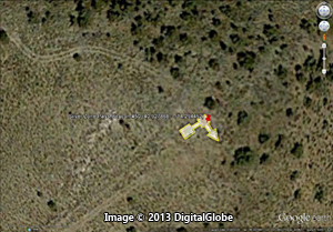
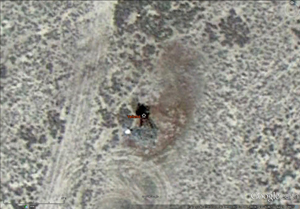
Photo from Google Earth
Yellow outline highlights the arrow shape
|
Arrow and Beacon Photos |
Site Location |
|
 |
 |
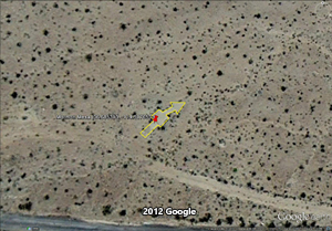
22 LA-SL Enterprise / Sloan
NEVADA: Clark County
CAM #4 Los Angeles-Salt Lake
Los Angeles-Las Vegas section
gps: 35.953291, -115.179291
|
 |
|
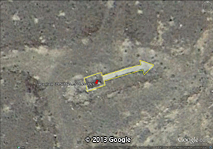
28 LA-SL Dry Lake
NEVADA: Clark County
CAM #4 Los Angeles-Salt Lake
Las Vegas-New Harmony Section
gps: 36.447638, -114.833027 |
 |
****This beacon site is on the Moapa River Indian Reservation. Obtain permission before visiting this location!*** |
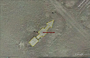
29 LA-SL Ute
NEVADA: Clark County
CAM #4 Los Angeles-Salt Lake
Las Vegas-New Harmony Section
gps: 36.540803, -114.710304 |
|
|
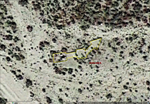
31 LA-SL Mormon Mesa
NEVADA: Clark County
CAM #4 Los Angeles-Salt Lake
Las Vegas-New Harmony Section
gps: 36.685313, -114.517653
|
 |
Arrow and location submitted by
Corbin Van Nest
|
32 LA-SL
Mormon Mesa /
29B LA-SL Narrows DOCILF
NEVADA: Clark County
CAM #4 Los Angeles-Salt Lake
Las Vegas-New Harmony Section
CAM #4 Los Angeles CA- Salt Lake City UT
gps: 36.796807, -114.246536
|
|
 |
Arrow and location submitted by
Robert Gowdy |
18 SF-SL Mogul
NEVADA: Washoe County
CAM #18: San Francisco-Salt Lake airway
San Francisco-Reno section
gps: 39.510018, -119.922404
|
 |
|
Reno Air Mail Field / Blanch Field
NEVADA: Washoe County
CAM #18: San Francisco-Salt Lake airway
Reno-Elko section
Reno Air Mail Field / Blanch Field
|
 |
|
20 SF-SL Derby Dam
NEVADA: Washoe County
CAM #18: San Francisco-Salt Lake airway
Reno-Elko section
gps: 39.580850, -119.487350
|
 |
|
20 SF-SL Tracy Clark
NEVADA: Washoe County
CAM #18: San Francisco-Salt Lake airway
Reno-Elko section
gps: 39.578623, -119.490192
|
 |
 |
28 SF-SL Humboldt / Rochester / Buena Vista DOCILF
NEVADA: Pershing County
CAM #18: San Francisco-Salt Lake airway
Reno-Elko section
gps: 40.075377, -118.181521
|
 |
Geocaching Gallery Images
Panoramio | Google Maps Image |
303 SF-SL Polkinghorne Springs
NEVADA: Pershing County
CAM #18: San Francisco-Salt Lake airway
Reno-Elko section
gps: 40.228792, -117.741354 |
 |
Arrow and location submitted by:
Dick Simonsen

|
NEVADA: Lander County
CAM #18: San Francisco-Salt Lake airway
Reno-Elko section
gps: 40.345195, -117.347534
|
 |
|
32 SF-SL Needle Peak
NEVADA: Pershing County
CAM #18: San Francisco-Salt Lake airway
Reno-Elko section
gps: 40.315598, -117.506403 |
 |
|
35 SF-SL Battle Mt / Lander Airport
NEVADA: Lander County
CAM #18: San Francisco-Salt Lake airway
Reno-Elko section
gps: 40.608824, -116.873958
|
 |
|
36 SF-SL Mule Canyon
NEVADA: Lander County
CAM #18: San Francisco-Salt Lake airway
Reno-Elko section
40.562998, -116.695748 |
 |
|
37A SF-SL Beowawe
NEVADA: Eureka County
CAM #18: San Francisco-Salt Lake airway
Reno-Elko section
gps: 40.596078, -116.507777 |
 |
|
37A SF-SL Emigrant Pass
NEVADA: Eureka County
CAM #18: San Francisco-Salt Lake airway
Reno-Elko section
gps: 40.652859, -116.274250 |
 |
|
42 SF-SL Elko Air Mail Field Marker
NEVADA: Elko County
CAM #18: San Francisco-Salt Lake airway
Reno-Elko section
gps: 40.823741, -115.791495
|
 |
|
45 SF-SL Welcome
NEVADA: Elko County
CAM #18: San Francisco-Salt Lake airway
Elko-Salt Lake section
41.102691, -115.090430
|
 |
|
46B SF-SL Wells Airport
NEVADA: Elko County
CAM #18: San Francisco-Salt Lake airway
Elko-Salt Lake section
gps: 41.114654, -114.927391
|
 |
|
48 SF-SL Pequop Summit
NEVADA: Elko County
CAM #18: San Francisco-Salt Lake airway
Elko-Salt Lake section
gps: 41.080882, -114.558799 |
 |
|
48 SF-SL Ventosa / Tobar
Department of Commerce Intermediate Field
NEVADA: Elko County
CAM #18: San Francisco-Salt Lake airway
Elko-Salt Lake section
gps: 40.857931, -114.804965 |
 |
|
49A SF-SL Little Lake Pass
NEVADA: Elko County
CAM #18: San Francisco-Salt Lake airway
Elko-Salt Lake section
gps: 40.829239, -114.579719
|
 |
 |
49B SF-SL Shafter DOCILF
NEVADA: Elko County
CAM #18: San Francisco-Salt Lake airway
Elko-Salt Lake section
gps: 40.851696, -114.440217
|
 |
|
501 mile SF-SL Hardy Creek
NEVADA: Elko County
CAM #18: San Francisco-Salt Lake airway
Elko-Salt Lake section
gps: 40.881409, -114.397957
|
 |

|
50 SF-SL Silver Zone Pass
NEVADA: Elko County
CAM #18: San Francisco-Salt Lake airway
Elko-Salt Lake section
gps: 40.927868, -114.294452
|
|
 |
|
26A SF-SL Granite Point /Lovelock / Derby Field
NEVADA: Pershing County
CAM #18: San Francisco-Salt Lake airway
Reno-Elko section
gps: 40.069792, -118.570921
|
 |

|
27 SF-SL Coal Canyon / Oreana
NEVADA: Pershing County
CAM #18: San Francisco-Salt Lake airway
Reno-Elko section
gps: 40.295988, -118.351783
|
 |
Arrow and location submitted by:
Ray Hawkins |
31 SF-SL Mill City
NEVADA: Pershing County
CAM #18: San Francisco-Salt Lake airway
Reno-Elko section
gps: 40.757962, -118.022690
|
 |
|
33 SF-SL Winnemucca DOCILF
NEVADA: Humboldt County
CAM #18: San Francisco-Salt Lake airway
Reno-Elko section
gps: 40.904677, -117.801225
|
 |
Arrow and location submitted by Dave DuPree
via Tom Johnson
|
34 SF-SL Eglon
NEVADA: Humboldt County
CAM #18: San Francisco-Salt Lake airway
Reno-Elko section
gps: 41.007369, -117.592923
|
 |
 |
35 SF-SL Golconda
NEVADA: Humboldt County
CAM #18: San Francisco-Salt Lake airway
Reno-Elko section
gps: 40.925068, -117.398107
|
 |

|
36A SF-SL Pumpernickle /
Iron Point DOCILF
NEVADA: Humboldt County
CAM #18: San Francisco-Salt Lake airway
Reno-Elko section
gps: 40.909402, -117.285699
|
 |
 |
36B SF-SL Stonehouse
NEVADA: Humboldt County
CAM #18: San Francisco-Salt Lake airway
Reno-Elko section
gps: 40.846553, -117.193631
|
 |

|
37 SF-SL Mote
NEVADA: Humbolt County
CAM #18: San Francisco-Salt Lake airway
Reno-Elko section
gps: 40.740119, -117.063519
|
Unknown Airway / Airports |
 |
|
Ely Airport
NEVADA: White Pine County
gps: 39.301585, -114.834670
|
 |
|
Tonopah Beacon
NEVADA: Nye County
gps: 38.085167, -117.175916 |
Alabama | Arizona | Arkansas | California | Colorado | Connecticut | Delaware | Florida | Georgia | Idaho | Illinois | Indiana | Iowa | Kansas
Kentucky | Louisiana | Maine | Maryland | Massachusetts | Michigan | Minnesota | Mississippi | Missouri | Montana | Nebraska | Nevada
New Hampshire | New Jersey | New Mexico | New York | North Carolina | North Dakota | Ohio | Oklahoma | Oregon | Pennsylvania
Rhode Island | South Carolina | South Dakota | Tennessee | Texas | Utah | Vermont | Virginia | Washington | West Virginia | Wisconsin | Wyoming |