Photo from Google Earth
Yellow outline highlights the arrow shape
|
Arrow and Beacon Photos |
Site Location |
C.A.M. #8
SF-S (San Francisco-Seattle) |
 |
|
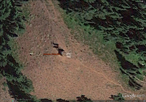
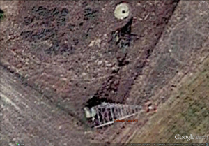
61A SF-S Kelso-Longview
Washington: Cowlitz County
CAM #8 Los Angeles-Seattle
San Francisco-Seattle Airway
Portland-Seattle Section
Pacific Air Transport September 15, 1926
GPS: 46.122956, -122.906448 |
 |
|
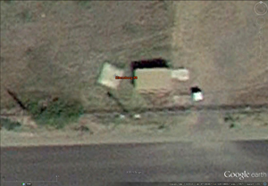
63B SF-S Toledo DOCILF
Washington: Lewis County
CAM #8 Los Angeles-Seattle
San Francisco-Seattle Airway
Portland-Seattle Section
Pacific Air Transport September 15, 1926
GPS: 46.476443, -122.816588 |
 |
|
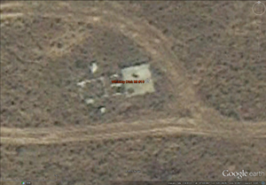
66 SF-S Chehalis-Centralia
Washington: Lewis County
CAM #8 Los Angeles-Seattle
San Francisco-Seattle Airway
Portland-Seattle Section
Pacific Air Transport September 15, 1926
GPS: 46.673739, -122.987076 |
C.A.M. #32
P-S (Portland-Spokane Airway) |
 |
|
20 P-S Pasco/Tri-Cities Airport
Washington: Franklin County
CAM #32 Pasco-Spokane/Seattle-Portland
Portland-Spokane Airway
Pasco-Spokane Section
Varney Air Lines September 15, 1929
GPS: 46.257357, -119.114326 |
 |
THIS ARROW HAS BEEN
DESTROYED! |
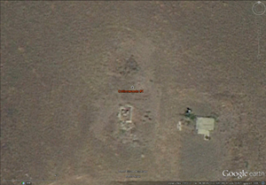
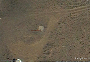
25 P-S Lind DOCILF
Washington: Adams County
|
 |
Jeff Stein found this arrow 2018
He reports, "Private Property"
"NO TRESPASSING SIGNS" |
32_30 P-S Tyler
WASHINGTON: Spokane County
|
 |
|
Spokane Airport/Felts Field
Washington: Spokane County
CAM #32 Pasco-Spokane/Seattle-Portland
Portland-Spokane Airway
Pasco-Spokane Section
Varney Air Lines September 15, 1929
GPS: 47.680663, -117.319422 |
Northern Transcontinental Route
Seattle-Helena Airway |
 |
|
Rattlesnake Mt.
Washington: King County
Northern Transcontinental Airway
Richfield Airway
GPS: 47.451345, -121.803535 |
 |
|
Kachess Ridge mile 55 blinker
Washington: Kittitas County
Northern Transcontinental Airway
Seattle-Helena Airway
GPS: 47.282117, -121.177419 |
 |
|
Teanaway #7
Washington: Kittitas County
Northern Transcontinental Airway
Seattle-Helena Airway
GPS: 47.151012, -120.790546 |
 |
|
Ellensburg #8
Washington: Kittitas County
Northern Transcontinental Airway
Seattle-Helena Airway
GPS: 47.031944, -120.529167 |
 |
|
Whiskey Dick Mt. #10
Washington: Kittitas County
Northern Transcontinental Airway
Seattle-Helena Airway
GPS: 47.103967, -120.236660 |
 |
|
Ephrata #13B
Washington: Grant County
Northern Transcontinental Airway
Seattle-Helena Airway
GPS: 47.311716, -119.521064 |
|
|
Coffepot Lake #18
Washington: Lincoln County
Northern Transcontinental Airway
Seattle-Helena Airway
GPS: 47.426886, -118.622585 |
 |
|
La Crosse West #28
Washington: Whitman County
Spokane-Pendleton Airway
GPS: 46.794303, -117.923810 |
Unknown Airway or Beacon # |
 |
Most likely a metal arrow |
The Cottonwoods #1
Washington: Kittitas County
GPS: 46.840205, -120.528121 |
 |
|
Pangborn Field
Washington: Douglas County
GPS: 47.403241, -120.206851 |

|
|
Pullman-Moscow
Washington: Whitman County
GPS: 46.745877, -117.108092
|
 |
|
Rock Island Dam #1
Washington: Douglas County
GPS: 47.363262, -120.077305 |
Arrows were know to be at the following Washington locations. If the intermediate fields had arrows, it is very likely that the beacons between fields also had arrows.
Happy Hunting. |
Cheney
Department of Commerce intermediate field, site 31, Portland-Spokane Airway. Seven-tenths mile N. Altitude, 2,335 feet. Irregular shape, 28 acres, 1,950 feet N./S., sandy, level, natural drainage. Directional arrow marked "31 P-S." Pole line and trees to W., trees to SE., beacon tower on hill to W. Beacon, boundary, approach, and obstruction lights. Beacon, 24-inch rotating, with green course lights flashing characteristic "1" (.__). Aviation fuel. No other servicing facilities. The W. and N. sides of field are surrounded by high ground, so that during a W. wind, blowing causes a down drop on the field.
Department of Commerce Intermediate field, site 31. Portland-Spokane Airway. N. side of city, within city limits. Altitude, 2,335 feet Irregular shape, 28 acres, 1,950 feet N/S., sandy, level, natural drainage. Directional arrow marked "31 P-S." Pole line and trees to W., trees to SB., beacon tower on hill to W. Beacon, boundary, approach, and obstruction lights. Beacon, 24-inch rotating, with green course lights flashing characteristic "1" (. ). Aviation fuel. No other servicing facilities. The W. and N. sides of field are surrounded by high ground, so that during a W. wind, blowing causes a down drop on the field.
|
Connell
(P-S Site No. 21).—A 24-inch, 2,000.000-candlepower rotating beacon, showing 6 rotations per minute, elevation of main beam above horizon 1 ½ °, is in operation 10 miles southwest of Connell. Concrete directional arrow at base of tower has forward bearing N. 9° W., backward bearing S. 13° W.
Department of Commerce intermediate field, site 22, Portland-Spokane Airway. One-fourth mile S. Altitude, 870 feet. L shape, 52 acres, sod, level, natural drainage; two landing strips, 2,428 by 550 feet and 2,165 by 660 feet. Directional arrow marked "22 P-S." Pole line to E., pole line 200 feet to N. and NW. Beacon, boundary, approach, and obstruction lights. Beacon, 24 inch rotating, with green course lights flashing characteristic "2" (.._). Aviation fuel. No other servicing facilities.
Department of Commerce intermediate field, site 22, Portland-Spokane Airway. One-fourth mile S. Altitude, 870 feet. L shape, 52 acres, sod, level, natural drainage; two landing strips, 2,350 by 500 feet B./W. and 2,196 by 660 feet N./S. Directional arrow marked "22 P-S." Pole line to B., pole line 200 feet to N. and NW. Beacon, boundary, approach, and obstruction lights. Beacon, 24-inch rotating, with green course lights flashing characteristic "2" (. .—). Aviation fuel. No other servicing facilities.
|
The Grand Dalles
Department of Commerce intermediate field, site 7A. Portland-Spokane Airway. One and one-fourth miles E. Altitude, 200 feet. Irregular shape, 88 acres, 2,700 by 1,600 feet, sod, level, natural drainage. Directional arrow marked "7 P-S." Power line to S. Beacon, boundary, approach, and obstruction lights. Beacon, 24-inch rotating, with green course lights flashing characteristic "7" ( . .). Aviation fuel. No other servicing facilities. Teletype.
(P-S Site No. 7-A).—A 7,500 candlepower 360° flashing white code beacon light is in operation at the intermediate landing field located 1½ miles north of The Dalles, latitude 45° 37' 30": longitude 121° 10': altitude 210 feet. Beacon code is: Dash, dot, dot (_ _ .). An illuminated wind cone is mounted on the beacon tower which is located in the northeast corner of the field. The directional arrow at the base of the tower has bearings: Forward N. 57" E.; backward N. 83* W. A 50-foot circle marks the field. Green approach lights indicate the east and west runway which Is 2.785 by 1.002" feet. The whole field is available for landing. Gradient, level: drainage, good; soil, sandy. Metal cones painted chrome yellow mounted on standards outline the field for day marking: white lights mark the boundaries at night. This field is regular in shape and there are no obstructions except the beacon tower.
Department of Commerce Intermediate field, site 7A, Port-land-Spokane Airway. One and one-fourth miles E. Altitude, 200 feet. Irregular shape, 88 acres, 2,700 by 1,600 feet, sod, level, natural drainage. Directional arrow marked "7 P-S." Power line to S. Beacon, boundary, approach, and obstruction lights. Beacon, green flashing characteristic "7" (_..). Aviation fuel. No other servicing facilities. Teletypewriter. Department of Commerce marker beacon, characteristic signal "D" (—. .), operating frequencies 248 and 278 kc. and radio range beacon, identifying signal " D "(_..), operating frequency 248 kc.
|
Kelso
Department of Commerce intermediate field, site 61A, San Francisco-Seattle Airway. One mile S. Altitude, 26 feet. Triangular, 75 acres, 2,404 by 1,987 by 1,770 feet; sod, level, natural drainage. Directional arrow marked "61A SF-S." KELSO on hangar roof. Pole lines to W. and S., trees and buildings to N, trees to NE. Beacon, boundary, approach, and obstruction lights. Beacon, 24-inch rotating, with green course lights flashing characteristic "1" (. _—). Small hangar and aviation fuel. No other servicing facilities.
Department of Commerce Intermediate field, site 61A, San Francisco-Seattle Airway. One mile S. Altitude, 26 feet. Triangular, 50 acres, 2.404 by 1,987 by 1.770 feet, sod, level, natural drainage; three landing strips, 1,650 feet N./S., 2.200 feet NW./SE., 1,850 feet E./W. Directional arrow marked "61A, SF-S." Pole lines to W. and S., trees and buildings to N.,- trees to NE. Beacon, boundary, approach, and obstruction lights. Beacon, green, flashing characteristic "1" (. __). Small hangar and aviation fuel. No other servicing facilities.
|
Lind
Department of Commerce intermediate field, site 25, Portland-Spokane Airway. One mile B. Altitude, 1,361 feet. Irregular shape, 60 acres, 2,025 by 1,761 feet, sod, level, natural drainage. Directional arrow marked "25 P-S." Pole line to S. and SW., beacon tower to SW. Beacon and boundary lights. Beacon, 24-inch rotating, with green course lights flashing characteristic "5" (. — .). Aviation fuel, day and night. No other servicing facilities.
Department of Commerce intermediate field, site 25, Portland-Spokane Airway. One mile E. Altitude, 1,361 feet. Irregular shape, 60 acres, 2,025 by 1,761 feet, sod, level, natural drainage. Directional arrow marked "2a P-S." Pole line to S. and SW., beacon tower to SW. Beacon and boundary lights. Beacon, 24-inch rotating, with green course lights flashing characteristic "5" (._.)• Aviation fuel, day and night. No other servicing facilities.
|
Sprague
Department of Commerce intermediate field, site 28, Portland-Spokane Airway. Five and one-half miles SW. Altitude, 1,942 feet T shape, 26 acres, sandy, level, natural drainage; two landing strips 2,400 by 300 feet N./S., 1,700 by 300 feet E./W. Directional arrow marked "28 P-S." Pole line to W., beacon tower to SE. Beacon, boundary, and approach lights. Beacon, 24-inch rotating, with green course lights flashing characteristic "8" (_...). Aviation fuel. No other servicing facilities.
Department of Commerce intermediate field, site 28, Portland Spokane Airway. Five and one-half miles SW. of city. Altitude, 1,942 feet. T shape, 26 acres, sandy, level, natural drainage; two landing strips, KE./SW. 2,730 feet; E./W. 1,650 feet. Directional arrow marked "28 P-S." >ole line to W.; beacon tower in SE. angle of field. Beacon, boundary, and approach lights. Beacon, 24-inch rotating, with green course lights flashing characteristic "8" (— . . .). Aviation fuel. No servicing facilities.
|
|
This site provides historical information only, do not use for navigation purposes.
Arrows and Beacons may be on private property, DO NOT TRESSPASS!
ALL photos are copyrighted and may not be used without written permission,
other than for personal use.
Arranged by CAM Route and Beacon #. This is a work in progress and will be constantly updated as new information is found. |
Alabama | Arizona | Arkansas | California | Colorado | Connecticut | Delaware | Florida | Georgia | Idaho | Illinois | Indiana | Iowa | Kansas
Kentucky | Louisiana | Maine | Maryland | Massachusetts | Michigan | Minnesota | Mississippi | Missouri | Montana | Nebraska | Nevada
New Hampshire | New Jersey | New Mexico | New York | North Carolina | North Dakota | Ohio | Oklahoma | Oregon | Pennsylvania
Rhode Island | South Carolina | South Dakota | Tennessee | Texas | Utah | Vermont | Virginia | Washington | West Virginia | Wisconsin | Wyoming |
|