Photo from Google Earth
Yellow outline highlights the arrow shape
|
Arrow and Beacon Photos |
Site Location |
|

|

|
9 SL-P Strevell DOCILF
Idaho: Cassia County
CAM #5 Elko NV- Pasco WA April 6, 1926
Salt Lake City UT- Pasco WA October 1, 1926
Varney Air Lines
42.01097,-113.205818
|

|
|
12 SL-P Idahome DOCILF
Idaho: Cassia County
CAM #5 Elko NV- Pasco WA April 6, 1926
Salt Lake City UT- Pasco WA October 1, 1926
Varney Air Lines
National Geodetic Survey Data Sheet NU1711
42.415687, -113.399801
|
 |
 |
14A SL-P Lake Walcott DOCILF
Idaho: Cassia County
CAM #5 Elko NV- Pasco WA April 6, 1926
Salt Lake City UT- Pasco WA October 1, 1926
Varney Air Lines
National Geodetic Survey Data Sheet NU1678
42.541296, -113.455847
|
 |
|
Burley Airport
Idaho: Cassia County
CAM #5 Elko NV- Pasco WA April 6, 1926
Salt Lake City UT- Pasco WA October 1, 1926
Varney Air Lines
42.539535, -113.768395
|
 |
|
Jerome Airport
Idaho: Jerome County
CAM #5 Elko NV- Pasco WA April 6, 1926
Salt Lake City UT- Pasco WA October 1, 1926
Varney Air Lines
42.725201, -114.455826
|
 |
 |
Gooding Airport
Idaho: Gooding County
CAM #5 Elko NV- Pasco WA April 6, 1926
Salt Lake City UT- Pasco WA October 1, 1926
Varney Air Lines
National Geodetic Survey Data Sheet NV1108
42.918688, -114.765462 |
 |
|
23B SL-P Hot Springs Creek
Idaho: Elmore County
CAM #5 Elko NV- Pasco WA April 6, 1926
Salt Lake City UT- Pasco WA October 1, 1926
Varney Air Lines
National Geodetic Survey Data Sheet OZ1010
43.027395, -115.380548
|
 |
 |
23A SL-P Glenns Ferry
Idaho: Elmore County
CAM #5 Elko NV- Pasco WA April 6, 1926
Salt Lake City UT- Pasco WA October 1, 1926
Varney Air Lines
National Geodetic Survey Data Sheet NV1144
42.991293, -115.374181
|
 |
 |
25 SL-P Mt. Home DOCILF
Idaho: Elmore County
CAM #5 Elko NV- Pasco WA April 6, 1926
Salt Lake City UT- Pasco WA October 1, 1926
Varney Air Lines
National Geodetic Survey Data Sheet OZ1042
43.126915, -115.727483
|
 |
 |
26 SL-P Crater Rings
Idaho: Elmore County
CAM #5 Elko NV- Pasco WA April 6, 1926
Salt Lake City UT- Pasco WA October 1, 1926
Varney Air Lines
National Geodetic Survey Data Sheet OZ1045
43.245908, -115.807600
|
 |
 |
27 SL-P Regena
Idaho: Elmore County
CAM #5 Elko NV- Pasco WA April 6, 1926
Salt Lake City UT- Pasco WA October 1, 1926
Varney Air Lines
43.365799,-115.956761
|
 |
 |
29 SL-P Boise South
Idaho: Ada County
CAM #5 Elko NV- Pasco WA April 6, 1926
Salt Lake City UT- Pasco WA October 1, 1926
Varney Air Lines
National Geodetic Survey Data Sheet OH1234
43.503414, -116.127834
|
 |
|
33 SL-P Birding Island
Idaho: Payette County
CAM #5 Elko NV- Pasco WA April 6, 1926
Salt Lake City UT- Pasco WA October 1, 1926
Varney Air Lines
National Geodetic Survey Data Sheet QB1302
44.019459, -116.762166 |
 |
|
36 SL-P Olds Ferry
Idaho: Washington County
CAM #5 Elko NV- Pasco WA April 6, 1926
Salt Lake City UT- Pasco WA October 1, 1926
Varney Air Lines
National Geodetic Survey Data Sheet QB1221
44.327188, -117.166630 |
|

|
|
1st 10 SL-GF Malad DOCILF / 2nd Malad City Airport (MLD)
Idaho: Oneida County
CAM #26 Great Falls-Salt Lake City
Salt Lake-Great Falls airway
National Parks Airways August 1, 1928
gps: 42.16628, -112.287262
|
 |
|
Pocatello Airport
Idaho: Power County
CAM #26 Great Falls-Salt Lake City
Salt Lake-Great Falls airway
National Parks Airways August 1, 1928
42.907143, -112.587237 |
 |
|
Idaho Falls Airport
Idaho: Bonneville County
CAM #26 Great Falls-Salt Lake City
Salt Lake-Great Falls airway
National Parks Airways August 1, 1928
gps: 43.517056, -112.060016
|
 |
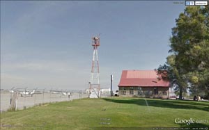
Original Beacon Station
Arrow, Beacon & Generator Shed
|
24 SL-GF Dubois DOCILF
Idaho: Clark County
CAM #26 Great Falls-Salt Lake City
Salt Lake-Great Falls airway
National Parks Airways August 1, 1928
National Geodetic Survey Data Sheet PZ0669
44.168858, -112.224350
|
 |
|
26 SL-GF Monida
Idaho: Clark County
CAM #26 Great Falls-Salt Lake City
Salt Lake-Great Falls airway
National Parks Airways August 1, 1928
National Geodetic Survey Data Sheet PZ0637
gps: 44.558610, -112.288459
26 SL-GF Monida Pass Website |
 |
|
Montpellier Bear Lake Airport
Idaho: Bear Lake County
National Geodetic Survey Data Sheet NT0555
42.253858, -111.336051
|
Contract Air Mail Route No. 26
All currently known information, if you know of something not listed please let us know.
| Beacon # |
CAM # |
gps |
Name |
City / Quad |
County |
State |
| 9 |
26.0 |
42.05933, -112.239556 |
9 SL-GF Woodruff |
Woodruff |
Oneida |
Idaho |
| 10 |
26.0 |
42.16628, -112.287262 |
10 SL-GF Malad DOCILF |
Malad |
Oneida |
Idaho |
| 11 |
26.0 |
42.414157, -112.507887 |
11 GF-SL Arbon |
Arbon |
Oneida |
Idaho |
| 11 |
26.0 |
|
11A SL-GF Daniels |
Daniels |
Oneida |
Idaho |
| 11 |
26.0 |
|
11B SL-GF Dairy Creek |
Dairy Creek |
Oneida |
Idaho |
| 12 |
26.0 |
42.553079, -112.556119 |
12 SL-GF Pauline DOCILF |
Pauline |
Power |
Idaho |
| 123 |
26.0 |
|
123 blinker Dairy Creek |
Dairy Creek |
Power |
Idaho |
| 13 |
26.0 |
42.692760, -112.597683 |
13 SL-GF Flatiron Hill |
Flatiron Hill |
Power |
Idaho |
| 13 |
26.0 |
42.724449, -112.534296 |
13 SL-GF Crystal |
Crystal |
Power |
Idaho |
| 14 |
26.0 |
42.909627, -112.539886 |
McDougall Field |
Pocatello |
Power |
Idaho |
| 14 |
26.0 |
42.907143, -112.587237 |
Pocatello Airport |
Pocatello |
Power |
Idaho |
| 140 |
26.0 |
|
14.0 Blinker |
Wheatgrass |
Power |
Idaho |
| 15 |
26.0 |
43.103067, -112.389090 |
15 SL-GF Fort Hall |
Fort Hall |
Bingham |
Idaho |
| 17 |
26.0 |
43.359132, -112.188978 |
17 SL-GF Firth |
Firth |
Bingham |
Idaho |
| 19 |
26.0 |
43.517056, -112.060016 |
Idaho Falls Airport |
Idaho Falls |
Bonneville |
Idaho |
| 20 |
26.0 |
43.722780, -112.106702 |
20 SL-GF Lewisville |
Lewisville |
Jefferson |
Idaho |
| 22 |
26.0 |
43.962389, -112.167981 |
22 SL-GF Hamer |
Hamer |
Jefferson |
Idaho |
| 24 |
26.0 |
44.168858, -112.224350 |
24 SL-GF Dubois DOCILF |
Dubois |
Clark |
Idaho |
| 25 |
26.0 |
44.378169, -112.194678 |
25 SL-GF Spencer N. |
Spencer North |
Clark |
Idaho |
| 26 |
26.0 |
44.558623, -112.288488 |
26 SL-GF Monida Pass |
Monida Pass |
Clark |
Idaho |
|
Alabama | Arizona | Arkansas | California | Colorado | Connecticut | Delaware | Florida | Georgia | Idaho | Illinois | Indiana | Iowa | Kansas
Kentucky | Louisiana | Maine | Maryland | Massachusetts | Michigan | Minnesota | Mississippi | Missouri | Montana | Nebraska | Nevada
New Hampshire | New Jersey | New Mexico | New York | North Carolina | North Dakota | Ohio | Oklahoma | Oregon | Pennsylvania
Rhode Island | South Carolina | South Dakota | Tennessee | Texas | Utah | Vermont | Virginia | Washington | West Virginia | Wisconsin | Wyoming |