 |
|
 |
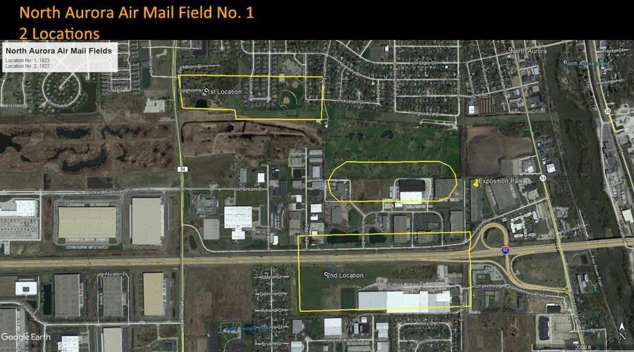
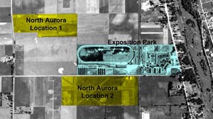
North Aurora Air Mail Field 2 Locations |

|
|
|
North Aurora Air Mail Field
No. 1 (1923-1927)
First Location GPS: 41.802028, -88.345241 |
|
| From the "Air Mail Trails" collection of Alice Eakle Marks, submitted by Melissa Marks Van Drew |
Location / Airway |
Location / Name
ILLINOIS: Aurora Township, Kane County
North Aurora Emergency Air Mail Field No. 1,
GPS: 41.802028, -88.345241
Transcontinental Airway
Route established
Night Airmail
Flights started on
Contract Air Mail
CAM #18 San Francisco CA-Chicago IL
Route established July 1, 1927
Omaha-Chicago Airway
Boeing Air Transport awarded CAM #18 on January 28, 1927
|
|
|
Observations and Notes |
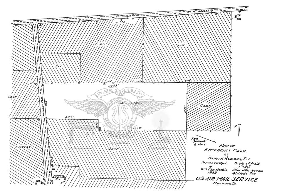
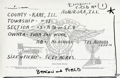
Emergency Landing Field Lease with Owners name, December 31, 1927
Alice Eakle Marks collection:
Emergency Landing Field, Central Division, No. 1,
J.J. Winn, North Aurora, Ill.,
45 acres, start date April 15, 1923,
Annual rental $300.00
email from Melissa Marks Van Drew dated: Sun 12/10/2017 6:03 PM
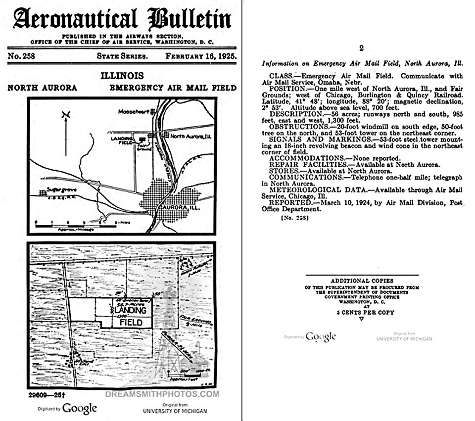
Aeronautical Bulletin No. 258, page 2, February 16, 1925
Information on Emergency Air Mail Field, North Aurora, III.
CLASS.—Emergency Air Mail Field. Communicate with Air Mail Service, Omaha, Nebr.
POSITION.—One mile west of North Aurora, Ill., and Fair Grounds; west of Chicago, Burlington & Quincy Railroad. Latitude, 41° 48'; longitude, 88° 20'; magnetic declination, 2° 53'. Altitude above sea level, 700 feet.
DESCRIPTION.—56 acres; runways north and south, 985 feet, east and west, 1,300 feet.
OBSTRUCTIONS.—20-foot windmill on south edge, 50-foot tree on the north, and 53-foot tower on the northeast corner.
SIGNALS AND MARKINGS.—53-foot steel tower mounting an 18-inch revolving beacon and wind cone in the northeast corner of field.
ACCOMMODATIONS.—None reported.
REPAIR FACILITIES.—Available at North Aurora.
STORES.—Available at North Aurora.
COMMUNICATIONS.—Telephone one-half mile; telegraph in North Aurora.
REPORTED.—March 10, 1924, by Air Mail Division, Post Office Department.
1925 Aircraft Year Book page 268, July 1, 1925
Air Mail Service Post Office: Emergency Field, privately owned.
1926 Aircraft Year Book page 284, July 1, 1926
Fields, Equipment and Ownership, Postal Airway: emergency field, 24" beacon and boundary lights, private owner.
|
North Aurora Air Mail Field
No. 1 (1927-?)
Second Location GPS: |
|
 |
Location / Airway |
Location / Name
ILLINOIS: Aurora Township, Kane County
AKA
GPS:
Transcontinental Airway
Route established
Night Airmail
Flights started on
Contract Air Mail
CAM #18 San Francisco CA-Chicago IL
Route established July 1, 1927
Omaha-Chicago Airway
Boeing Air Transport awarded CAM #18 on January 28, 1927
|
Observations and Notes |
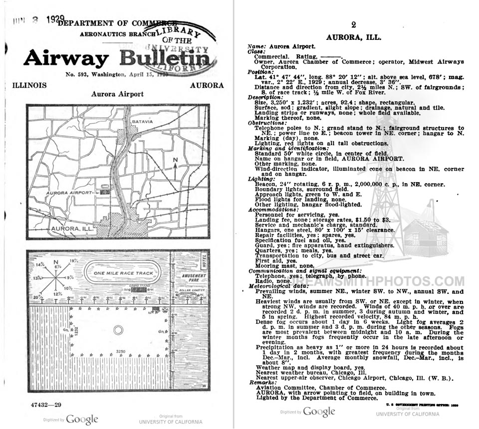
Airway Bulletin No. 593, page 2, April 15, 1929
AURORA, ILL. Name: Aurora Airport.
Class: Commercial. Rating. Owner, Aurora Chamber of Commerce; operator, Midwest Airways Corporation.
Position: Lat. 41° 47' 44"", Long. 88° 20' 12""; alt. above sea level, 678'; mag. var., 2° 22' E., 1929; annual decrease, 3' 36". Distance and direction from city, 2½ miles N.; SW. of fairgrounds; S. of race track; ½ mile W. of Fox River.
Description: Size, 3,250' x 1,232'; acres 92.4; shape, rectangular. Surface, sod; gradient, slight slope; drainage, natural and tile. Landing strips or runways, none; whole field available. Marking thereof, none.
Obstructions: Telephone poles to N.; grand stand to N.; fairground structures to NE.; power line to E.; beacon tower in NE. corner; hangar to N. Marking (day), none. Lighting, red lights on all tall obstructions. Marking and identification: Standard 50' white circle, in center of field. Name on hangar or in field, AURORA AIRPORT. Other marking, none. Wind-direction indicator, illuminated cone on beacon in NE. corner and on hangar.
Lighting: Beacon, 24"" rotating, 6 r. p. m., 2,000,000 c. p., in NE. corner. Boundary lights, surround field. Approach lights, green to W. and E. Flood lights for landing, none. Other lighting, hangar flood-lighted.
Accommodations: Personnel for servicing, yes. Landing fee, none; storage rates, $1.50 to $3. Service and mechanic's charge, standard. Hangars, one steel, 80' x 100' x 15' clearance. Repair facilities, yes; spares, yes. Specification fuel and oil, yes. Guard, yes; fire apparatus, hand extinguishers. Quarters, yes; meals, yes. Transportation to city, bus and street car. First aid, yes. Mooring mast, none.
Communication and signal equipment: Telephone, yes; telegraph, by phone. Radio, none.
Remarks: Aviation Committee, Chamber of Commerce. AURORA, with arrow pointing to field, on building in town. Lighted by the Department of Commerce.
Airway Bulletin No.2, page 42, September 1, 1931
Aurora, Illinois page 42 —Aurora Airport, commercial, rating. Two and one-half miles N; W. of Fox River. Altitude, 642 feet. Field L shape, 120 acres, sod, slightly high in center, natural and tile drainage. AURORA AIRPORT on hangar roof. Pole lines to N. and E., buildings to NE. Beacon, boundary, approach, and obstruction lights. Beacon, 24-inch rotating, with green course lights flashing characteristic " 10" ( ). Facilities for servicing aircraft, day and night. Radio-communication station, operator, Boeing Air Transport, call letters WQDU, operating frequencies 278, 3172, and 5660 kcs. Teletype.
Air Commerce Bulletin Vol. 03 No. 09, page 240, November 2, 1931
Aurora, III.—The airport 2½ miles north of Aurora, described in Airway Bulletin No. 593, is now an L-shaped field, the north-south area on the west side having been increased to 3,250 feet.
Air Commerce Bulletin Vol. 03 No. 17, page 419, March 1, 1932
Aurora, III.—The radio communication station and teletypewriter have been removed from Aurora Airport, 2 ½ miles north of Aurora, just west of Fox River. Pole lines to north, east, and west. This airport is described on page 42 of Airway Bulletin No. 2, Descriptions of Airports and Landing Fields in the United States.
Air Commerce Bulletin Vol. 03 No. 23, page 600, June 1, 1932
Aurora, III.—The description of Aurora Airport, 2 ½ miles north of Aurora, appearing on page 42 of Airway Bulletin No. 2, should be changed to show it to be a rectangular tract measuring 1,243 feet north-south by 3,231 feet east-west, the extension to the south of the west portion having been abandoned. Boundary lights indicate new area.
Airway Bulletin No. 46, September 1, 1932
Aurora.—Midwest Airways Airport, commercial, rating . Three miles N. of Aurora, just W. of Fox River. Altitude, 642 feet. Rectangular, 93 acres, 1,243 feet N./S. by 3,231 feet E./W., sod, slightly high in center, natural and artificial drainage; entire field available. AURORA AIRPORT on hangar roof. Pole lines to N. and E., buildings to NE. Beacon, boundary, approach, and obstruction lights. Beacon, 24-inch rotating, with green course lights flashing characteristic "10" ( ). Facilities for servicing aircraft, day and night, by appointment or call.
|
Make a comment on our Facebook Page "Arrows Across America" about this arrow.

|
This site provides historical information only, do not use for navigation purposes.
Arrows and Beacons may be on private property, DO NOT TRESSPASS!
ALL photos are copyrighted and may not be used without written permission
other than for personal use. |
|
Alabama | Arizona | Arkansas | California | Colorado | Connecticut | Delaware | Florida | Georgia | Idaho | Illinois | Indiana | Iowa | Kansas
Kentucky | Louisiana | Maine | Maryland | Massachusetts | Michigan | Minnesota | Mississippi | Missouri | Montana | Nebraska | Nevada
New Hampshire | New Jersey | New Mexico | New York | North Carolina | North Dakota | Ohio | Oklahoma | Oregon | Pennsylvania
Rhode Island | South Carolina | South Dakota | Tennessee | Texas | Utah | Vermont | Virginia | Washington | West Virginia | Wisconsin | Wyoming |
|