|
|||||||
|
|||||||
 |
|||||||
| Click on small photo to see large version
|
 |
||||||
Drone Photos |
|||||||
| Must have a FAA Certified Drone Pilots License to fly at this location! | |||||||
Click on small photo to see large version |
|||||||
Contributors Photos |
|||||||
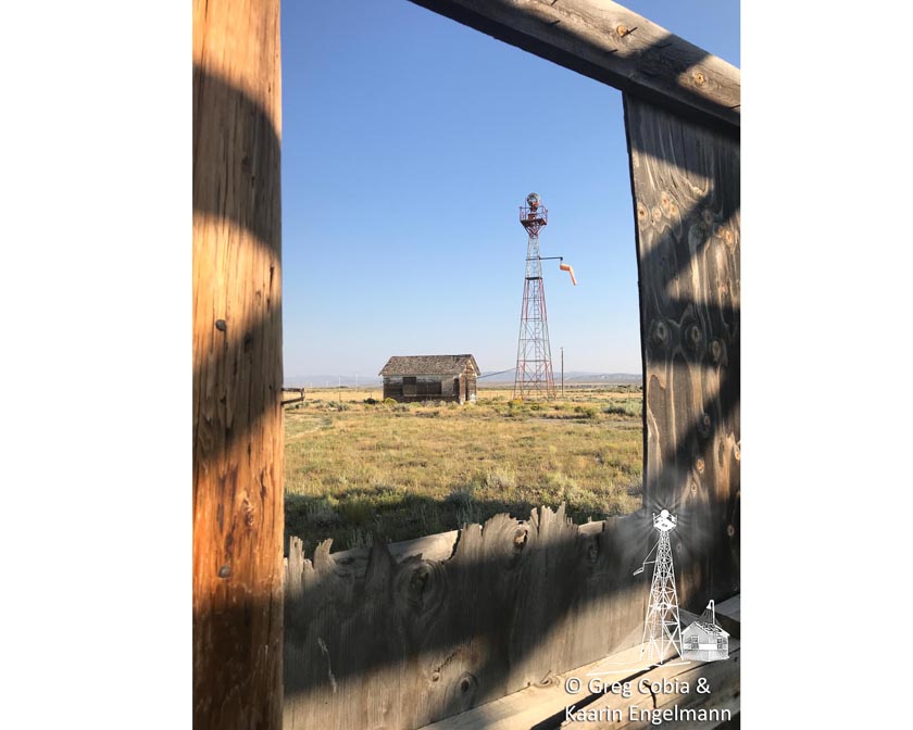
Courtesy of Greg Cobia and Kaarin Engelmann August 11, 2018 |
|||||||
Click on small photo to see large version
|
 |
||||||
Location / Airway |
|||||||
Location / Name
Transcontinental Airway
|
|||||||
Observations and Notes |
|||||||
The Medicine Bow Arrow is located in a small airport approximately ½ mile off of Hwy 30 in the town of Medicine Bow, Wyoming. The road to the airport is a county maintained dirt road. We were able to drive right to the arrow. This arrow was the most unique of our trip because in addition to the arrow (which was complete), it still had the original beacon tower (and beacon) & original generator shed. I found this amazing due to the harsh weather conditions that exist here during the winter. The arrow is in good condition with only a few minor cracks. The tower & beacon are also in fairly good condition, the glass has been broken out of the beacon. The generator shed is weathered and has been vandalized, but still retains some of its original paint. The arrow is only 47 feet in length. This arrow is located at an airport making the use of a drone within 5 miles of it or any airport prohibited under Federal regulations without an FAA certification. Brian recieved his FAA Certified Drone Pilots License in December 2017, so we were able to take drone photos here on June 26, 2018 during Arrow Quest 2018 . The pilot would approach the tail of the arrow on a compass heading of 83° (basically East), and then exit the arrow on a compass heading of 138° (S-SE). (All measurements and compass headings are approximate). |
|||||||
Links |
|||||||
 |
|||||||
|
|||||||
National Register of Historic Places Application
|
|||||||
|
Make a comment on our Facebook Page "Arrows Across America" about this arrow.
|
|||||||
|
|||||||
| This site provides historical information only, do not use for navigation purposes. Arrows and Beacons may be on private property, DO NOT TRESSPASS! ALL photos are copyrighted and may not be used without written permission other than for personal use. |
|||||||
| Alabama | Arizona | Arkansas | California | Colorado | Connecticut | Delaware | Florida | Georgia | Idaho | Illinois | Indiana | Iowa | Kansas Kentucky | Louisiana | Maine | Maryland | Massachusetts | Michigan | Minnesota | Mississippi | Missouri | Montana | Nebraska | Nevada New Hampshire | New Jersey | New Mexico | New York | North Carolina | North Dakota | Ohio | Oklahoma | Oregon | Pennsylvania Rhode Island | South Carolina | South Dakota | Tennessee | Texas | Utah | Vermont | Virginia | Washington | West Virginia | Wisconsin | Wyoming |
|||||||


