| Home | Arrows & Beacons | Time Line | Air Mail Routes | Contributors/ Photo Credits |
Contact Info |
Cincinatti-Chicago Airway
This site provides historical information only, do not use for navigation purposes.
|
||||
Cincinatti-Chicago Airway |
||||
| SECTION MAP (01) | NAME |
GPS |
PID |
CITY or USGS Quad |
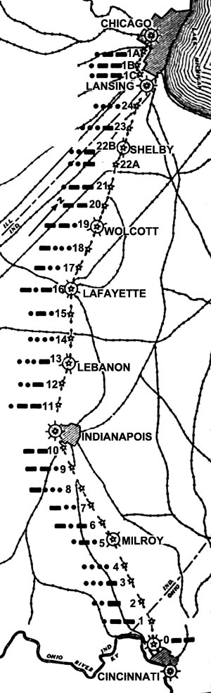 |
Chicago | Chicago IL | ||
| 1A | ||||
| 1B | ||||
| 1C | ||||
| Lansing | Lansing | |||
| 24 C-C | ||||
| 23 C-C | ||||
| 22B C-C Shelby DOCILF | Shelby | |||
| 22A C-C | ||||
| 21 C-C | ||||
| 20 C-C | ||||
| 19 C-C Wolcott DOCILF | Wolcott | |||
| 18 C-C | ||||
| 17 C-C | ||||
| 16 C-C Lafayette DOCILF | Lafayette | |||
| 15 C-C | ||||
| 14 C-C | ||||
| 13 C-C Lebanon DOCILF | Lebanon | |||
| 12 | ||||
| 11 C-C | ||||
| Indianapolis | Indianapolis | |||
| 10 C-C | ||||
| 9 C-C | ||||
| 8 C-C | ||||
| 7 C-C | ||||
| 6 C-C Rushville | 39.506896, -85.515725 | Milroy IN | ||
| 5 C-C Milroy DOCILF | 39.467996, -85.367022 | JZ3342 | Milroy IN | |
| 04 C-C Peppertown | 3/4 mile northwest of | Peppertown IN | ||
| 03 C-C Brookville | 39.358533, -85.071530 | JZ3326 | Brookville IN | |
| 02 C-C New Trenton | 39.305415, -84.921138 | JZ3266 | ||
| 1 C-C | 39.254819, -84.773818 | JZ3263 | Harrison OH | |
| 0 C-C | ||||
| Lunken Airport | 39.103786, -84.429289 | Cincinnati OH | ||
Links |
||||
|
||||
CAM Routes |
||||
| CAM # 1 | CAM # 2 | CAM # 3 | CAM # 4 | CAM # 5 | CAM # 6 | CAM # 7 | CAM # 8 | CAM # 9 | CAM # 10 | ||||
| CAM #11 | CAM #12 | CAM #13 | CAM #14 | CAM #15 | CAM #16 | CAM #17 | CAM #18 | CAM #19 | CAM #20 | ||||
| CAM #21 | CAM #22 | CAM #23 | CAM #24 | CAM #25 | CAM #26 | CAM #27 | CAM #28 | CAM #29 | CAM #30 | ||||
| CAM #31 | CAM #32 | CAM #33 | CAM # 34 | ||||
Arrows and Beacons may be on private property, DO NOT TRESSPASS! |
||||
