This site provides historical information only, do not use for navigation purposes. |
 |
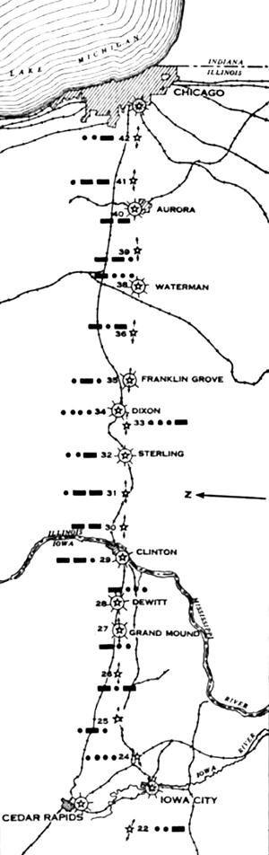
Iowa City-Chicago Section
Sectional aeronautical charts: |
| SECTION MAP |
NAME |
GPS |
PID |
City/Quad/County |
 |
| Chicago |
|
|
|
| 18_40 North Aurora |
41.795005, -88.330531 |
|
Kane Co., Illinois |
| 18_39 O-C Kaneville |
|
|
Kane Co., Illinois |
| 18_38 O-C Waterman |
41.769517, -88.756127 |
|
DeKalb Co., Illinois |
| 18_36 O-C Scarboro |
41.786497, -89.020658 |
|
Lee Co., Illinois |
| 18_35 O-C Franklin Grove DOCILF |
41.796311, -89.276969 |
|
Lee Co., Illinois |
| 18_34 O-C Dixon Municipal- Charles R. Walgreen Field |
41.837499, -89.444215 |
MF1604 |
Lee Co., Illinois |
| 18_33 O-C |
|
|
Lee Co., Illinois |
| 18_32 O-C Sterling |
41.811341, -89.698793 |
MF1728 |
Whiteside Co., Illinois |
| 18_31 O-C Morrison |
|
|
Whiteside Co., Illinois |
| 18_30 O-C Garden Plain |
|
|
Whiteside Co., Illinois |
| 18_29 O-C Clinton |
41.782604, -90.254647 |
|
Clinton Co., Iowa |
| 18_28 O-C Dewitt |
41.808628, -90.519276 |
|
Clinton Co., Iowa |
| 18_27 O-C Grand Mound |
41.803108,-90.664285 |
|
Clinton Co., Iowa |
| 18_26 O-C Dixon |
|
|
Clinton Co., Iowa |
| 18_25 O-C Tipton |
41.792575, -91.169324 |
|
Cedar Co., Iowa |
| 18_24 O-C West Branch |
41.700001, -91.366663 |
|
Johnson Co., Iowa |
| Iowa City-Smith Field |
41.639576, -91.541260 |
|
Johnson Co., Iowa |
| Cedar Rapids |
|
|
|
|
Links |
| |
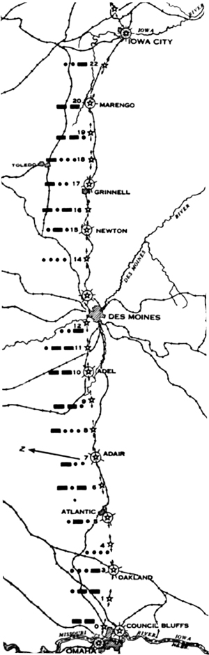
Omaha to Iowa City Section
Sectional aeronautical charts: |
| SECTION MAP |
NAME |
GPS |
PID |
City/Quad/County |
 |
| Iowa City-Smith Field |
41.639576, -91.541260 |
|
Johnson Co., Iowa |
| 18_22 O-C Oxford |
|
|
Johnson Co., Iowa |
| 18_20 O-C Marengo DOCILF |
41.782000, -92.084639 |
MH0459 |
Iowa Co., Iowa |
| 18_19 O-C Victor |
41.763463, -92.296508 |
|
Iowa Co., Iowa |
| 18_18 O-C Brooklyn |
41.745255, -92.511879 |
|
Poweshiek Co., Iowa |
| 18_17 O-C Grinnell DOCILF |
41.730823, -92.688059 |
|
Poweshiek Co., Iowa |
| 18_16 O-C Kellogg |
41.716667, -92.883336 |
|
Jasper Co., Iowa |
| 18_17 O-C Newton DOCILF |
41.704384, -93.029381 |
|
Jasper Co., Iowa |
| 18_14 O-C Colfax |
41.680911, -93.234952 |
MH0617 |
Jasper Co., Iowa |
| 18_Des Moines-Hanna Field |
41.650000, -93.472500 |
|
Polk Co., Iowa |
| 18_12 O-C |
|
|
Polk Co., Iowa |
| 18_11 O-C |
|
|
|
| 18_10 O-C Adel DOCILF |
41.607003, -94.050390 |
|
Dallas Co., Iowa |
| 18_09 O-C Stuart |
41.460669, -94.260803 |
MJ1097 |
|
| 18_09 O-C Stuart DOCILF |
41.465556, -94.262778 |
|
|
| 18_08 O-C Casey |
41.443582, -94.528167 |
MJ1099 |
|
| 18_08 O-C Casey DOCILF |
41.504710, -94.518304 |
|
|
| 18_07 O-C Adar |
|
|
|
| 18_06 O-C |
|
|
|
| 18_05 O-C Anita |
41.413826, -94.806310 |
MJ1112 |
|
| 18_05 O-C Atlantic DOCILF |
41.405556, -95.046111 |
|
|
| 18_04 O-C Atlantic |
41.404055, -95.062392 |
MJ1181 |
|
| 18_03 O-C Oakland DOCILF |
41.297778, -95.421389 |
|
|
| 18_01 O-C Airway Beacon |
41.325529, -95.614307 |
MJ1203 |
|
| 18_00 O-C |
|
|
|
| Council Bluffs |
|
|
|
| Eppley Airfield |
41.301354, -95.893619 |
|
Pottawattamie Co., Nebraska |
|
| 18_22 O-C Oxford |
|
|
|
| 18_18 O-C Williamsburg DOCILF |
|
|
|
| 18_19 O-C Deep River |
|
|
|
| 18_18 O-C Montezuma DOCILF |
41.579167, -92.454167 |
|
|
| 18_17 O-C Searsboro |
|
|
|
| 18_16 O-C Sully |
|
|
|
| 18_15 O-C Reasnor DOCILF |
|
|
|
| 18_14 O-C Prairie City |
|
|
|
| |
|
|
|
|
Links |
| |
|
Airway Bulletin No. 1, page 41 September 1, 1931
Airway Bulletin No. 1, page 45, September 1, 1932 |
CAM Routes |
| CAM # 1 | CAM # 2 | CAM # 3 | CAM # 4 | CAM # 5 | CAM # 6 | CAM # 7 | CAM # 8 | CAM # 9 | CAM # 10 |
| CAM #11 | CAM #12 | CAM #13 | CAM #14 | CAM #15 | CAM #16 | CAM #17 | CAM #18 | CAM #19 | CAM #20 |
| CAM #21 | CAM #22 | CAM #23 | CAM #24 | CAM #25 | CAM #26 | CAM #27 | CAM #28 | CAM #29 | CAM #30 |
| CAM #31 | CAM #32 | CAM #33 | CAM # 34 |
Arrows and Beacons may be on private property, DO NOT TRESSPASS!
This is a work in progress and will be constantly updated as new information is found. |
|