 |
|
Columbus-Philadelphia Airway |
This site provides historical information only, do not use for navigation purposes. |
 |
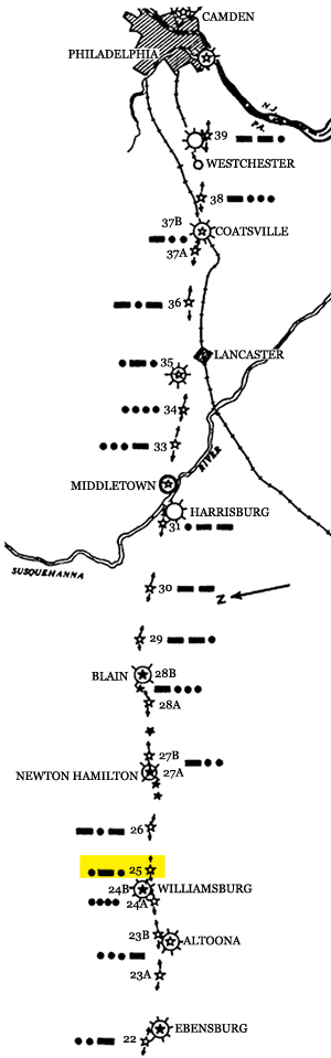
Ebensburg-Philadelphia Section
Sectional aeronautical charts: |
| SECTION MAP |
NAME |
GPS |
PID |
County, State |
|
| |
|
|
|
| |
|
|
|
| 39 C-P |
|
|
|
| |
|
|
|
| 38 C-P |
|
|
|
| Coatsville |
|
|
|
| 37A C-P |
|
|
|
| 36 C-P |
|
|
|
| Lancaster |
|
|
|
| 35 C-P |
|
|
|
34 C-P |
|
|
|
| 33 C-P |
|
|
|
| Middletown |
|
|
|
| Harrisburg |
|
|
|
| 31 C-P Lemoyne |
40.224876, -76.877630 |
|
|
| 30 C-P |
|
|
|
| 29B C-P |
|
|
|
| 28B Blain DOCILF |
|
|
|
| 28A |
|
|
|
| 27B C-P |
|
|
|
| 27A C-P Newton Hamilton DOCILF |
|
|
|
| blinker |
|
|
|
| blinker |
|
|
|
| 26 C-P |
|
|
|
| 25 C-P Williamsburg |
40.421633, -78.168200 |
|
|
| 24B C-P Williamsburg |
40.453889, -78.238889 |
|
|
| 24A |
|
|
|
| 23B Altoona |
|
|
|
| 23A |
|
|
|
| Keystone Airport |
40.458734, -78.775648 |
|
|
| |
|
|
|
| |
|
|
|
| |
|
|
|
|
Links |
| |
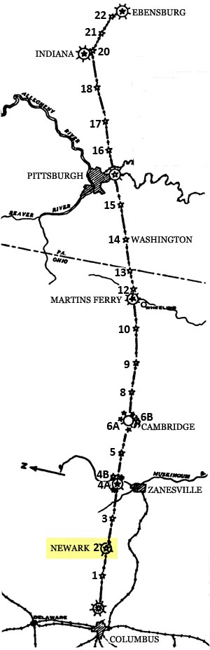
Columbus-Ebensburg Section
Sectional aeronautical charts: |
| SECTION MAP |
NAME |
GPS |
PID |
County, State |
|
| Keystone Airport |
40.458734, -78.775648 |
|
|
| 22 C-P |
|
|
|
| 21 C-P Vintondale |
40.439398, -78.905457 |
KX2314 |
|
| 20 C-P Indiana DOCILF |
|
|
|
| 20 C-P Bolivar |
40.448475, -79.157272 |
KX1996 |
|
18 C-P Slicksville |
40.401244, -79.519513 |
KX2022 |
|
| 17 C-P Delmont |
|
|
|
| 16 C-P |
|
|
|
| Bettis Field |
40.356947, -79.898375 |
|
|
| 15 C-P McMurry |
40.298999, -80.082944 |
KY3087 |
|
| 14 C-P Canonsburg |
40.288175, -80.163947 |
KY3096 |
|
| 14 C-P Washington |
40.233609, -80.336807 |
KY3139 |
|
| 13C-P Bethany |
40.184360, -80.537639 |
KY3167 |
|
| 12 C-P Tiltonsville |
40.141638, -80.677849 |
KY3202 |
|
| Scott Field |
searching for |
|
|
| 10 C-P St. Clairsville |
40.102163, -80.926134 |
|
|
| 9 C-P Hendrysburg |
40.075218, -81.165312 |
|
|
| 09 C-P Fairview |
40.071214, -81.172636 |
KY3417 |
|
| 8 C-P |
|
|
|
| 6.70 C-P blinker |
|
|
|
| 6.75 C-P blinker |
|
|
|
| 6.775 C-P blinker |
|
|
|
| blinker |
|
|
|
| 6B C-P Cambridge DOCILF |
40.045110,-81.570049 |
KY3438 |
|
| blinker |
|
|
|
| 6A C-P Cambridge DOCILF |
40.048889, -81.579722 |
|
|
| 5 C-P |
40.048275, -81.795511 |
|
|
| 4.4 C-P blinker |
|
|
|
| 4.3 C-P blinker |
|
|
|
| 4B C-P Dresden |
40.042239, -82.023786 |
KZ1831 |
|
| 4A Zanesville DOCILF |
40.035278, -82.033333 |
|
|
| 3 C-P Toboso |
40.023089, -82.248550 |
KZ1836 |
|
| 2 C-P Newark DOCILF |
40.022605, -82.464253 |
KZ1847 |
|
| 1 C-P |
|
|
|
| Port of Columbus |
39.986918, -82.871871 |
|
|
|
Links |
| |
|