|
|||||||
32 LA-SL Mormon MesaGPS: 36.796807, -114.246536 |
|||||||
 |
|||||||
| Click on small photo to see large version
|
 |
||||||
Location / Airway |
|||||||
Location / Name
Contract Air Mail
Operator
|
|||||||
Drone Photos |
|||||||
 |
|||||||
|
|||||||
Observations and Notes |
|||||||
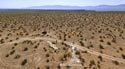
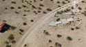
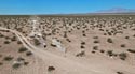
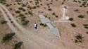
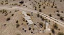
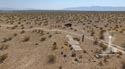
This photo shows the various names given to this beacon. On the 1929 map it was 33, 1930 map it was 33, 1935 map it was 30. In the strip maps it was 30 in 1931, and 1932. The Mormon Mesa #30 Arrow is fairly close to the southbound lanes of I-15. Upon leaving Las Vegas we drove northbound on I-15 and exited at SR-170. Crossing over the freeway we then drove southbound for 1.5 miles before pulling into a ‘truck pull-out’ alongside the freeway. The dirt road to the arrow begins at the pullout. There was no gate at this location. The drive to the arrow is 2 miles. The dirt road is level but very rocky. Four-wheel drive was not necessary, but our top speed was barely 5 miles mph. The arrow is complete and in good condition. The arrow is 58 feet in length. The pilot would approach the tail of the arrow on a compass heading of 84° (E), and then exit the arrow on a compass heading of 84° (E). (All measurements and compass headings are approximate). |
|||||||
Panoramic |
|||||||
 |
|||||||
Contributors Photos |
|||||||
Submitted by Corbin Van Nes |
|||||||
 |
|||||||
Links |
|||||||
|
|||||||
|
Make a comment on our Facebook Page "Arrows Across America" about this arrow.
|
|||||||
| This site provides historical information only, do not use for navigation purposes. Arrows and Beacons may be on private property, DO NOT TRESSPASS! ALL photos are copyrighted and may not be used without written permission other than for personal use. |
|||||||
|
|||||||
| Alabama | Arizona | Arkansas | California | Colorado | Connecticut | Delaware | Florida | Georgia | Idaho | Illinois | Indiana | Iowa | Kansas Kentucky | Louisiana | Maine | Maryland | Massachusetts | Michigan | Minnesota | Mississippi | Missouri | Montana | Nebraska | Nevada New Hampshire | New Jersey | New Mexico | New York | North Carolina | North Dakota | Ohio | Oklahoma | Oregon | Pennsylvania Rhode Island | South Carolina | South Dakota | Tennessee | Texas | Utah | Vermont | Virginia | Washington | West Virginia | Wisconsin | Wyoming |
|||||||


 Click on this link to see larger photo

